Affichage des articles dont le libellé est Doklam Plateau. Afficher tous les articles

samedi 12 août 2017

Chinese Aggressions

India Steps Up Alert Amid Heightened Tensions With China
By SCOTT NEUMAN

Exiled Tibetans shout slogans during a protest to show support for India on the Doklam standoff in New Delhi, India, on Friday. Tsering Topgyal/AP

India has increased a military alert along its eastern border with China, moving troops and weapons into the region amid a weeks-long standoff between the two countries that shows no signs of resolution.
As NPR's Julie McCarthy reported last month, New Delhi and Beijing have been at odds over a strategic region called the Doklam Plateau, which is claimed both by China and by India's tiny ally, Bhutan.
In June, China began construction to extend a road there in an apparent effort to press its claim. 
In response, India sent troops as a show of force, sparking anger from China which says the affair is none of its business.
Beijing demanded that Indian forces withdrawal, but Indian Prime Minister Narendra Modi has refused.
India's Defense Minister Arun Jaitley told parliament this week that the country's armed forces are "fully prepared" in the event of conflict with China.
Meanwhile, Reuters reports that Indian troops in Sikkim, south of Doklam, have been put on heightened alert, although the news agency quoted an unnamed source as saying it was "out of caution."
In 1962, India and China fought a bloody month-long border war. 
The neighbors also have a continuing dispute over the sovereignty Aksai Chin, a Himalayan region on their extreme western border.
Doklam is strategically close to a sliver of land called the "Chicken's Neck" that is India's only land corridor to its frequently restive northeast.
The two countries have also long been at odds over India's hosting of Tibet's government-in-exile and their spiritual leader, the Dalai Lama, considered by China to be subversive.

lundi 7 août 2017

Chinese aggressions

China may conduct 'small-scale military operation' to remove Indian troops from Bhutan border region
By Samuel Osborne 

China could conduct a "small-scale military operation" to expel Indian troops from a contested region in the Himalayas, according to an article published a Chinese state-controlled newspaper.
Indian troops entered the area in the Doklam Plateau in June after New Delhi's ally Bhutan complained a Chinese military construction party was building a road inside Bhutan's territory.
Beijing says Doklam is located in Tibet and that the border dispute between China and Bhutan has nothing to do with India. 
It has demanded Indian troops withdraw.
Chinese and Indian media have taken a strident approach, with an article in the Chinese state-owned Global Times quoting a research fellow at the Institute of International Relations of the Shanghai Academy of Social Sciences saying China is preparing to initiate a "limited war" to push Indian soldiers out of the area.
Hu Zhiyong told the paper: "The series of remarks from the Chinese side within a 24-hour period sends a signal to India that there is no way China will tolerate the Indian troops' incursion into Chinese territory for too long.
"If India refuses to withdraw, China may conduct a small-scale military operation within two weeks."
He went on to say the military operation would aim to seize Indian personnel lingering in Chinese territory or expel them.
"India, which has stirred up the incident, should bear all the consequences," he added. 
"And no matter how the standoff ends, Sino-Indian ties have been severely damaged and strategic distrust will linger."
An Indian magazine's front cover last month showed a map of China shorn of Tibet and self-ruled Taiwan also ignited public anger on Chinese social media with thousands of angry posts.
The Indian government has asked political parties to refrain from politicising the issue and allow diplomacy to work.
Last week, China ramped up the rhetoric with China Central Television broadcasting a video it said showed an army unit in an unidentified part of Tibet carrying out live-fire firing exercises in the past few days.
A commander sitting in a vehicle shouted "Three, two, one, fire!" into two telephones and a missile was launched into the sky. 
Troops were shown loading and firing other missiles, some of which landed in fiery explosions.
The report, which was also carried in other state media, didn't mention the dispute with India, and said the unit has been training for three months.
It appeared to be an attempt to increase pressure on India, however, along with strongly worded statements this week from China's foreign and defence ministries, as well as in state media.
"China has made it clear that there is no room for negotiation and the only solution is the unconditional and immediate withdrawal of Indian troops from the region," said a commentary by the official Xinhua News Agency.
"If China backs down now, India may be emboldened to make more trouble in the future," it added.

The two sides' troops are confronting each other close to a valley controlled by China that separates India from its close ally, Bhutan, and gives China access to the Siliguri Corridor or Chicken's Neck, a thin strip of land connecting India and its remote northeastern regions.
In New Delhi, Sushma Swaraj, the minister for external affairs, told Parliament India was concerned about China's actions affecting the tri-junction boundary point between Bhutan, China and India as well as the India-China border.
She said India would "keep engaging with China to resolve the dispute."
"War is not a solution to anything," Ms Swaraj said. 
"Patience, control on comments and diplomacy can resolve problems."
Most previous standoffs, such as one in 2014 just ahead of a rare trip to India for Xi Jinping, were resolved with both sides withdrawing their forces.
There has been no shooting since a brief border war in 1962.

lundi 10 juillet 2017

The Necessary War

Chinese Troops Probe India. This Could Be China's Next War.
By Gordon G. Chang
On Friday, Xi Jinping and Indian Prime Minister Narendra Modi met on the sidelines of the Hamburg G-20. 
It is unclear if they discussed the most-recent border standoff between their two countries, in the Himalayas in Doklam.
The confrontation began June 16, when Indian troops stopped the Chinese from building a road in the disputed area.
Earlier, Chinese construction trucks, guarded by soldiers, had entered Doklam near the strategic “tri-junction,” where Bhutan, China, and India meet. 
The area is just north of the “chicken’s neck,” a narrow corridor of Indian territory connecting the main portion of the country to its northeast.
India and Bhutan maintain the disputed area belongs to Bhutan while China claims it as its own.
At the moment, Chinese and Indian troops are 120 meters apart, a “civil distance.”
The situation, according to the South China Morning Post, is the “most serious confrontation between the nations in over 30 years.”
Why did Beijing choose to create a provocation at this time? 
“The Chinese are making their unhappiness clear on India and America’s relationship,” said Sameer Patil of Gateway House, an Indian think tank, to the Washington Post. 
Apparently, the Chinese decided to begin road construction—in other words, start another cycle of provocation—when they learned of Modi’s visit to Washington.
Modi visited the White House on June 26, and there he bear-hugged President Trump, who had extended an especially warm welcome. 
Trump during the talks had set aside trade and immigration irritants so that he could continue Bush and Obama policy to strengthen links between the world’s most populous democracy and its most powerful one. 
“The relationship between India and the United States has never been stronger, has never been better,” Trump said in the Rose Garden as he accurately described ties. 
Moreover, the Chinese could not have been happy that Modi and Trump held an impromptu meeting at the G-20 on Saturday, a sign of the easy-going relationship the Indian and American leaders have developed.
Some argue the Doklam dispute will be resolved as other recent incidents have been. 
“There are institutional mechanisms between military officials as well as civilians to discuss such differences,” Rajeev Ranjan Chaturvedy of the National University of Singapore told the South China Morning Post. 
“My guess is that backchannel diplomacy is active already.”
My guess is that Chaturvedy is correct about the existence of discussions. 
Indian and Chinese officials always seem to talk during Chinese incursions.
Yet no solution is in sight in Bhutan. 
In fact, as Nitin Gokhale of the closely followed Bharat Shakti site tweeted Sunday, “there are no signs of de-escalation from either side.”
Moreover, there are, unlike in the past, worrying signs. 
On the Chinese side, there is a new mood of assertion. 
“I think the root cause is that the Chinese feel that their moment has arrived and that they do not need to accommodate Indian interests in any way, given the huge power differential in their favor,” says Ashley Tellis of the Carnegie Endowment for International Peace.
Xi Jinping, the Chinese ruler, has decided he has a duty to expand China, so we see aggressive moves all along the country’s periphery. 
Beijing wants Indian-controlled territory, and Chinese troops are, with regularity, penetrating deep into areas India consider to be its own.
On the Indian side, there is a new lack of tolerance for China’s belligerence. 
As the People’s Liberation Army continues to probe India, Indian policymakers realize they must hold their ground, literally and figuratively. 
“There is little appetite in India to accommodate China’s behavior,” notes Gateway House’s Patil.
Furthermore, China’s intransigence is pushing India toward the United States. 
And as India and the U.S. draw closer, Beijing sees more of a threat to its interests. 
As Tellis points out, “Chinese suspicion that India was casting its lot entirely with the United States has only intensified Beijing’s determination to be even less accommodative towards New Delhi.” China, in short, has created a self-destructive dynamic. 
That means armed conflict is becoming increasingly likely. 
Unfortunately, China’s Communist Party-controlled media is now threatening war over Doklam.
In a hawkish editorial titled “India Will Suffer Worse Losses than 1962 If It Incites Border Clash,” the Global Times, controlled by People’s Daily, made clear Beijing’s position on the sovereignty dispute. 
“The Indian military can choose to return to its territory with dignity, or be kicked out of the area by Chinese soldiers,” the nationalist tabloid threatened on Tuesday.
It is hard to see how Xi, who faces a crucial 19th Party Congress this fall, can give over Doklam to a country—and people—Chinese policymakers often view with disdain. 
Indians, who have every reason to be proud, will not surrender territory just because Beijing wants it and is willing to employ forceful tactics.
China has made a friend an adversary and is now making that adversary an enemy.

vendredi 7 juillet 2017

The Necessary War

What's behind the India-China border stand-off?
BBC News

India and China have a long history of border disputes

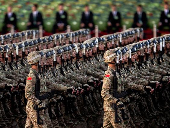
For four weeks, India and China have been involved in a stand-off along part of their 3,500km (2,174-mile) shared border.
The two nations fought a war over the border in 1962 and disputes remain unresolved in several areas, causing tensions to rise from time to time.
Since this confrontation began last month, each side has reinforced its troops and called on the other to back down.

How did the row begin?
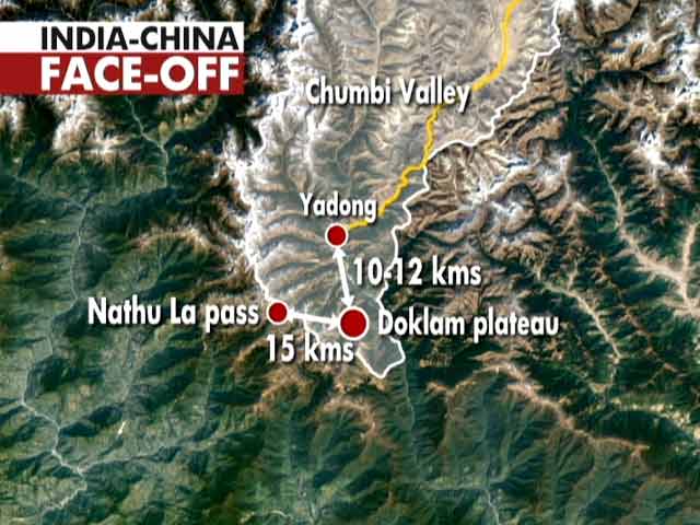
It erupted when India opposed China's attempt to extend a border road through a plateau known as Doklam.
The plateau, which lies at a junction between China, the north-eastern Indian state of Sikkim and Bhutan, is currently disputed between Beijing and Thimphu.
India supports Bhutan's claim over it.
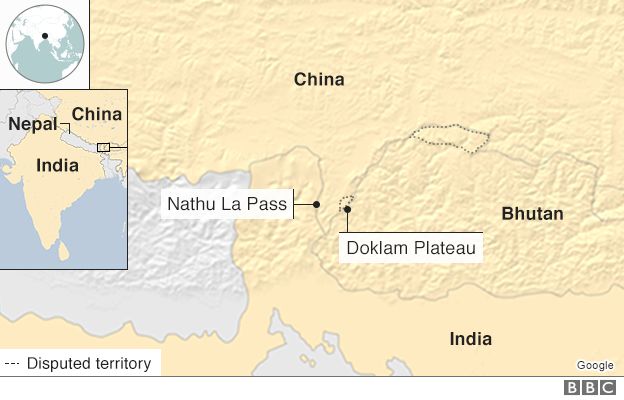
India is concerned that if the road is completed, it will give China greater access to India's strategically vulnerable "chicken's neck", a 20km (12-mile) wide corridor that links the seven north-eastern states to the Indian mainland.
Indian military officials told regional analyst Subir Bhaumik that they protested and stopped the road-building group, which led Chinese troops to rush Indian positions and smash two bunkers at the nearby Lalten outpost.
"We did not open fire, our boys just created a human wall and stopped the Chinese from any further incursion," a brigadier said on condition of anonymity because he was not authorised to speak to the press.
Chinese officials say that in opposing the road construction, Indian border guards obstructed "normal activities" on the Chinese side, and called on India to immediately withdraw.

What is the situation now?
Both India and China have rushed more troops to the border region, and media reports say the two sides are in an "eyeball to eyeball" stand-off.
The Chinese ambassador to India Luo Zhaohui told Press Trust of India news agency on Tuesday that India had to "unconditionally pull back troops" for peace to prevail.
The statement is being seen as a diplomatic escalation by China.
China also retaliated by stopping 57 Indian pilgrims who were on their way to the Manas Sarovar Lake in Tibet via the Nathu La pass in Sikkim.
The lake is a holy Hindu site and there is a formal agreement between the neighbours to allow devotees to visit.
Bhutan, meanwhile, has asked China to stop building the road, saying it is in violation of an agreement between the two countries.

What does India say?
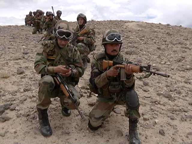
Indian military experts say Sikkim is the only area through which India could make an offensive response to a Chinese incursion, and the only stretch of the Himalayan frontier where Indian troops have a terrain and tactical advantage.
They have higher ground, and the Chinese positions there are squeezed between India and Bhutan.
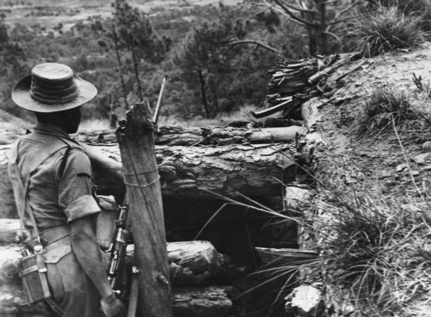
India and China fought a bitter war in 1962.

"The Chinese know this and so they are always trying to undo our advantage there," retired Maj-Gen Gaganjit Singh, who commanded troops on the border, told the BBC.
Last week, the foreign ministry said that the construction "would represent a significant change of status quo with serious security implications for India".
Indian Defence Minister Arun Jaitley also warned that the India of 2017 was not the India of 1962, and the country was well within its rights to defend its territorial integrity.

What does China say?
China has reiterated its sovereignty over the area, saying that the road is in its territory and accusing Indian troops of "trespassing".
It said India would do well to remember its defeat in the 1962 war, warning Delhi that China was also more powerful than it was then.
On Monday, a Chinese foreign ministry spokesman said that the border in Sikkim had been settled in an 1890 agreement with the British, and that India's violation of this was "very serious".
The Global Times newspaper, meanwhile, accused India of undermining Bhutan's sovereignty by interfering in the road project, although Bhutan has since asked China to stop construction.

What's Bhutan's role in this?
Bhutan's Ambassador to Delhi Vetsop Namgyel says China's road construction is "in violation of an agreement between the two countries".
Bhutan and China do not have formal relations but maintain contact through their missions in Delhi.
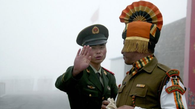
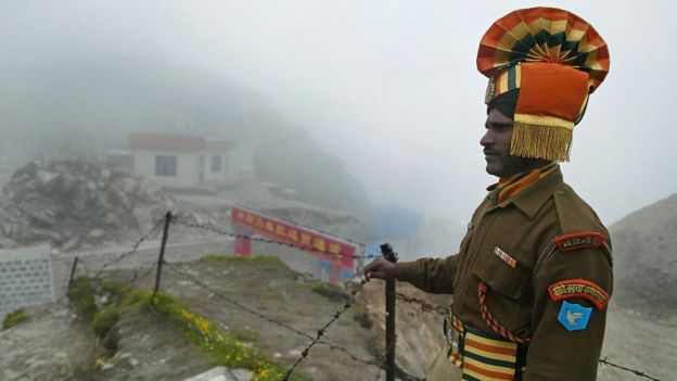
An Indian soldier on the China border.

Security analyst Jaideep Saikia told the BBC that Beijing had for a while now been trying to deal directly with Thimphu, which is Delhi's closest ally in South Asia.
"By raising the issue of Bhutan's sovereignty, they are trying to force Thimphu to turn to Beijing the way Nepal has," he said.

What next?
The region saw clashes between China and India in 1967, and tensions still flare occasionally. Commentators say the latest development appears to be one of the most serious escalations in recent years.
The fact that Tibet's spiritual leader, the Dalai Lama resides in India has also been a sticking point between the two countries.
This stand-off in fact, comes within weeks of China's furious protests against the Dalai Lama's visit to Arunachal Pradesh, an Indian state that China claims and describes as its own.
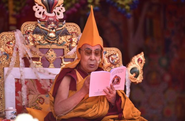
China recently protested against Tibetan spiritual leader Dalai Lama's visit to Arunachal Pradesh, an Indian state Beijing claims as its own.

Chinese Aggressions

In Armed Conflict With India, China Would Be Bigger Loser
By Samir Saran

The ongoing standoff at Doklam Plateau is less a boundary incident involving India, China and Bhutan and more a coming together of geopolitical faultlines in Asia that were long set on a collision course.
China's wanton aggression, and India's refusal to be intimidated by it, stem from the different realities they live in. 
China believes it is destined to lead Asia, and indeed the world, by a process in which other actors are but bit players. 
India is strongly convinced of its destiny as a great power and an indispensable player in any conversation to re-engineer global regimes.
It is against the backdrop of these competing ambitions that China's provocations on the Doklam Plateau must be viewed. 
As the race to establish an Asian order -- or at least determine who gets to define it -- intensifies, China will test Indian resolve and portray it as an unreliable partner to smaller neighbours. 
The current differential in capabilities allows China to provoke and understand the limits of India's political appetite for confrontation, and create a pattern of escalation and de-escalation that would have consequences for New Delhi's reputation. 
Its border transgressions are aimed at changing facts on the ground, and allowing for new terms of settlement. 
For China to engage in a game of chicken, however, would be counterproductive.
In case of an armed conflict, the bigger loser will be China. 
The very basis of its "Peaceful Rise" would be questioned and an aspiring world power would be recast as a neighbourhood bully, bogged down for the medium term in petty, regional quarrels with smaller countries. 
For India, a stalemate with a larger nuclear power will do it no harm and will change the terms of engagement with China dramatically.
Through the Doklam standoff, China has conveyed three messages. 
The first is that China seeks to utilize its economic and political clout to emerge as the sole continental power and only arbiter of peace in the region. 
Multipolarity is good for the world, not for Asia. 
When India refused to pay tribute in the court of Emperor Xi Jinping, through debt, bondage and political servility that the Belt and Road Initiative sought from all in China's periphery, it invited the wrath of the middle kingdom. 
Confrontation was but a matter of time.
The second message from Beijing is that short-term stability in Asia does not matter to China, because it does not eye Asian markets for its growth. 
Through road and rail infrastructure along the Eurasian landmass and sea routes across the Indian Ocean and the Mediterranean, China hopes to gain access to an eighteen trillion dollar European market. 
Given this reality, no Asian country can create incentives for China to alter its behavior simply with the promise of greater economic integration.
And finally, Beijing has signalled that Pax Sinica is not just an economic configuration, but also a military and political undertaking. 
Its aggressive posture in the South China Sea, disregard for Indian sovereignty in Jammu and Kashmir, divide and rule policy in the ASEAN region, and strategic investments in overseas ports such as Gwadar and Djibouti are all indicative of its intention to establish a Sino-centric economic and security architecture, through force if necessary. 
The election of Donald Trump in the United States and political divisions in Europe has only emboldened China's belief that the reigns of global power are theirs to grab.
Given these stark messages from the eastern front, what can New Delhi do?
The options are limited.
The first is to acquiesce to Chinese hegemony over Asia. 
In the past, India's foreign policy has attempted to co-opt China into a larger Asian project, from Nehru's insistence on China's position on the United Nations Security Council to facilitating its entry into the World Trade Organisation. 
It is clear today that it was the wrong approach and continuing to play second fiddle to the Chinese will not only involve political concessions but also territorial ones to China-backed adversaries like Pakistan.
The second option for India is to set credible red lines for China by escalating the cost for its aggressive maneuvers around India's periphery and to increase the cost of "land acquisition" for the Chinese.
Pakistan's approach vis-à-vis India may prove to be enlightening in this respect. 
Its development of Tactical Nuclear Weapons (TNW) to offset India's superior conventional abilities and a wide range of asymmetric warfare techniques have ensured that India is disproportionately engaged in regional affairs. 
For long, the Indian commentariat and diplomatic corps have believed the boundary dispute with China should be suppressed because the bilateral relationship is worth more than just territorial skirmishes. 
In doing so, they have normalised Beijing's behaviour, which now allows it to turn the tables and make unsettled boundaries a ceaseless source of tension for India. 
It is time, therefore, to elevate the boundary dispute as a matter of primary strategic concern and to articulate options to counter Beijing's threats on the eastern flank. 
It has done the former by staying away from a project that paid little heed to its sovereignty and territorial concerns. 
It is time to muster steel and to put together a blueprint for the latter.
China is attempting, vainly, to draw India into a conflict that it believes will prematurely invest it with the label of "first among equals" in Asia. 
Ironically, Beijing has failed to acknowledge that India does not have to behave like a 10 trillion dollar economy when it is not one -- skirmishes, like the one at Doklam Plateau, can be swiftly and aggressively countered by India with little or no loss to its reputation. 
After all, it would be defending its sovereignty, and in the process, goading China's smaller neighbours into a similar path. 
If China wants to be relegated to a disputed regional power, it has only to needle India into a new season of skirmishes and into exacerbating -- politically, militarily and diplomatically -- Beijing's multiple land and maritime disputes in Asia. 

The Necessary War

Chinese and Indian troops face off in Bhutan border dispute
By Michael Safi in Delhi

China has demanded the withdrawal of Indian troops from a scrap of disputed territory to end an escalating border row between the two Asian powers that has drawn in tiny Bhutan.
Beijing claims the Indian troops are occupying its soil, but both Bhutan and India maintain the area in question is Bhutanese territory.
Analysts say the harsh language and scale of the mobilisation in the remote but strategically important area, where the borders of China, India and Bhutan intersect, is unprecedented in recent years.
One former Indian foreign secretary said the impasse, now in its third week, also marked the first time India and China had squared off on the soil of a third country, an overt display of the escalating regional rivalry between the pair.
The current standoff began on 16 June when a column of Chinese troops accompanied by construction vehicles and road-building equipment began moving south into what Bhutan considers its territory.
Bhutan, a small Himalayan kingdom with close military and economic ties to India, requested assistance from Delhi, which sent forces to resist the Chinese advance.
To avoid escalation, frontline troops in the area do not generally carry weapons, and the Chinese and Indian troops reportedly clashed by “jostling”: bumping chests, without punching or kicking, in order to force the other side backwards.
At the heart of the dispute are different interpretations of where the “trijunction” – the point where the three countries’ borders meet – precisely lies. 
China argues its territory extends south to an area called Gamochen, while India says Chinese control ends at Batanga La, further to the north.
About 3,000 troops from both countries are reportedly stationed near Doklam, an area initial media reports said was about 15km from Gamochen, but which satellite imagery shows could be as close as two to three kilometres away.
In support of its claim, China points to an 1890 treaty signed with the British Raj, and seemingly endorsed by India’s first prime minister, Jawaharlal Nehru, in a letter to his Chinese counterpart. India says the letter does not accurately capture Nehru’s position and that China cannot unilaterally alter the territorial status quo.
It is the longest standoff between the two armies since 1962, when tensions over Tibet and elsewhere along the border sparked a brief war from which China emerged victorious.
China still claims a section of the Indian state of Arunachal Pradesh and was angered in April when the Dalai Lama, whom Beijing regards as an “anti-China separatist”, conducted a tour of the state.
Though India says its troops in Bhutan are in “non-combative mode”, the rhetoric on both sides is growing increasingly pugilistic. 
India’s army chief, Bipin Rawat, has said that India is ready to fight a “two and half front war” – referring to Pakistan, China and against the country’s various internal insurgencies.
On Tuesday, an editorial in the Global Times, a Chinese state-run newspaper, called for Delhi to be taught “a bitter lesson”, warning in a second conflict it would suffer greater losses than in 1962.
Global attention is usually focused on China’s expansion into east Asia, but the burgeoning superpower is increasingly also muscling into south Asia, forging links with countries India considers to be firmly within its sphere of influence.
“For the past six years China has been attempting to hem India in and take away its strategic space in South Asia,” said Ashok Malik, a fellow at the Delhi-based Observer Research Foundation.
India was especially sensitive to China’s encroachment near its Bhutanese border, he said, because it brought Chinese troops uncomfortably close to a section of Indian territory called the “chicken’s neck”, a thin corridor which, if broached, could cut Delhi off from its northeastern states.
“This is in fact a provocative gesture which makes the defence of Doklam virtually the defence of India,” Malik said. 
“I expect both sides to stay put as long as Chinese supply and logistical lines will allow.”

jeudi 6 juillet 2017

Truths Mapped Out: India Cannot Afford To Have China Controlling Doklam Plateau

Chinese incursion in a region which is disputed territory between China and Bhutan: Development in this area has serious security ramifications for India.
By Rohit Vats

As I write this, India finds itself in a border stand-off with China. 
But unlike other times when India and China squared off due to difference in ‘perception’ of Line of Actual Control (LAC) along their vast border from eastern Ladakh to Arunachal Pradesh, the present stand-off is because of Chinese incursion in a region which is disputed territory between China and Bhutan. 
India has gotten involved because development in this area has serious security ramifications for India.
However, none of the reports barring one gives correct information about the geographical region where this stand-off has taken place and the likely reason for this new conflict. 
Even the report by Manoj Joshi only gives a broad outline of the area.
The objective of this report is to understand the boundary issue, claims of either party (China and Bhutan), geography in the area and Indian sensitivities. 
The thrust of this write-up is to clear the ambiguity about the exact area, where the present stand-off is taking place, and why India is reacting much more strongly – to the extent of helping to keep the China’s People's Liberation Army (PLA) out of Bhutanese territory.

Story so far – Confusion!

When the news story broke, it spoke about the Chinese removing Indian Army bunkers in Tri-Junction Area after the Indian Army prevented the Chinese from undertaking road construction activity. 
These reports mentioned certain key areas like the tri-junction, Dhoka La and Doklam Plateau.
This caused confusion because if you look at the map on Google Earth, these areas are not contiguous. 
Have a look at the map below. 
I’ve marked position of Dhoka La, India (Sikkim)-Bhutan-China (Chumbi Valley) boundary tri-junction and Doklam Plateau (as shown on Google Earth). 
Doklam Plateau from the tri-junction is about 30 kilometres as the crow flies while Dhoka La is about 5 kilometres south of boundary tri-junction.

So, a question arises – if the Chinese were building a road in the Doklam plateau on the China-Bhutan border, how did the Indian Army stop their work? 
And how does the boundary tri-junction area and Dhoka La come into the picture?

Bhutan-China border dispute
As per the Royal Government of Bhutan (RGOB), there are four areas of boundary-alignment dispute between China and Bhutan. 
However, as per the Chinese, there are seven such areas of boundary dispute. 
It is this mismatch in the number and extent of disputed areas which has led to the present stand-off.
I’m not getting into the entire Bhutan-China boundary issue, but will restrict myself to the current area of conflict.
As per the statement of the King of Bhutan in the National Assembly, there are four areas under dispute:
1. Up to 89 sq km in Doklam are under dispute (along Gamochen at the border, to the river divide at Batangla and Sinchela, and down to the Amo Chhu River)
2. Approximately 180 sq km in Sinchulumpa and Gieu are under dispute. 
The border line stretches from Langmarpo Zam along the river up to Docherimchang, through the river divide to Gomla, along the river divide to Pangkala, and finally down to the Dramana River.
3. Starting from Dramana, along the border line up to Zingula, and along the line of river divide down to Gieu Chhu River, and finally to Lungkala
4. Starting from the middle of Pasamlum, along the border-line and the river divide to Dompala and Neula, going from Neula along the border line and the river divide to Kurichhu Tshozam, along the river divide to Genla then to Mela, and go all the way to the east.
Point (1) above is centred along and east of the India-Bhutan-China boundary tri-junction area. 
Point (2) refers to the area marked as Doklam plateau on Google Earth and shows as disputed with a broken line. 
As per the RGOB, there is no contiguity between areas covered under points (1) and (2) while Chinese claim an intermediate area as well. 
This makes the Chinese claims much larger than the Bhutanese interpretation and the root cause of the present conflict.
I’ve not been able to access any corresponding maps from the RGOB which show the alignment of the above area. 
As Joshi writes in his Indian Express article, “However, none of these features are visible on publicly available maps and it requires an effort to locate them.” 
I’ve created some indicative maps after searching through multiple sources and will come to that shortly.
And while I could not find any RGOB map showing disputed areas, I did come across a Chinese map which shows the seven disputed areas as per them. 
Please see the map below:

Areas with red and blue line indicate disputed areas as per the Chinese. 
The blue line indicates border alignment as per RGOB while the red line indicates the alignment of Bhutanese boundary as per the Chinese.
The disputed area in the west is the centre of the present conflict. 
And as per the Chinese, there are three major boundary alignment issues within this sector. 
Compared to this, RGOB claims only two non-contiguous areas of dispute. 
As the Chinese map shows, the Chinese claim is much larger than what the RGOB considers. 
The details of the three disputed areas in this region are as follows:
1. The mountain ridge from Batang La to Merukla/Merugla upto Sinchela
2. The mountain ridge from Sinchela to River Amo; along River Amo, from River Amo to its confluence with River Langmarpo;
3. Region along the River Langmarpo from the confluence of River Lang-marpo and River Amo up to the confluence of Docherimchang; along River Rong from River Docherimchang confluence to Gomla; Gomla ridge from Gomla to Pankala, and Pankala ridge from Pankala to Dramana ridge; Dramana ridge from Dramana to River Tromo and River Zhiu confluence, River Zhiu from River Tromo-River Zhiu confluence to Lungkala;
(Source: Bhutan News Service)
If you look at the RGOB and Chinese interpretation of the boundary dispute, you realise that point (1) in both the interpretations of boundary alignment is the same. 
But in case of the Chinese, point (2) and (3) taken together, create a contiguous disputed area and vastly expand the area which they claim as being part of Tibet. 
From the Bhutanese perspective, point (3) in the Chinese claim is the same as per their understanding but is not contiguous to area under Point (1).
The blow-out map below shows how the Chinese claims are with respect to present alignment:
Chinese claim line

I’ve tried to create the Chinese claim line on a Google Earth map by using features I could identify. These features correspond to those mentioned in Chinese claims as mentioned earlier.
Chinese claim line (Google Earth)
The Chinese are using their usual tactics – of claiming a ridge-line/water-shed (and corresponding mountain passes) which gives them depth and allows them to control west-east or vice versa movement. 
In case of Sino-Indian boundary in eastern Ladakh, the Chinese claim line lies along the ridge to the west of the Indian claim line and controls all the important mountain passes which can facilitate east-west or vice-versa movement. 
In this case, the boundary envelope has been pushed east with the following objectives:
1. Give depth to Chinese positions in the Chumbi Valley. As has been widely reported, Chumbi Valley is extremely narrow with steep mountain sides on either side. This gives very less real estate to the PLA to station troops and provisions. Further, this puts them at a disadvantage vis-a-vis the Indian position on the ridges to the west along the Sikkim-Tibet border.
2. The present main access route into Chumbi Valley and Yadong is S-204. Given the depth of the Chumbi Valley and its alignment, it is susceptible to Indian interdiction. The Chinese can consider developing a loop in S-204, which is further east and passes through the claimed area. This will give it a relatively better protection against Indian fire assault.
3. The most important gain is towards the south part – opens up the restricted funnel of Chumbi Valley and brings it that much closer to the Indian Siliguri corridor. The Indian area in the Siliguri corridor comes under long range artillery fire from within Chumbi Valley.

Doklam Plateau
The present stand-off is in the Doklam plateau area, region marked in blue circle in the previous map. If we revisit the Chinese boundary alignment claim in this region, it mentions the following:
1. Mountain ridge from Batang La to Merukla/Merugla upto Sinchela
2. The mountain ridge from Sinchela to River Amo; along River Amo from River Amo to its confluence with River Langmarpo
The map below highlights these areas and the alignment:
Doklam Plateau (Source: Google Earth)
In case Chinese assertions are expected, then the India-China-Bhutan boundary will be at Gymochen. And Dokal La, which is presently on the border between India (Sikkim) and Bhutan, will become a pass on the Sino-Indian border.
A closer look at the satellite imagery shows that a road leads up from the Chumbi Valley to Senche La, crosses over to Bhutanese side, runs parallel to the Merug La-Senche La ridge line and then crosses back into Chumbi Valley at Merug La. 
A part of this road/track from Senche La also comes towards Doka La. 
It seems that the Chinese have extended tracks from the Merug La-Sinche La ridge line onto the Doklam plateau and have over the years slowly creeped forward claiming and controlling a larger part of the plateau.
The map below shows various roads/tracks in the region:
Road tracks in the region (Source: Wikimapia)
Present Issue
What seems to be happening is that the Chinese are trying to further expand their hold on the plateau. 
From the available news, it seems that the Chinese were trying to create concrete roads in the region. The maps already show tracks which came about as Chinese saw no objection from RGOB. 
And in typical Chinese fashion, they’ll now claim existence of these tracks as proof of ownership — apart from historical claims.
Any further advance in this area poses a security threat to India. 
Working in tandem with RBA, the Indian Army seems to have stopped this construction activity within Doklam plateau. 
This partly explains the apoplectic response from the Chinese —Indian Army is operating on Bhutanese territory and working in tandem with RBA to prevent further Chinese construction activity. 
Hence, the repeated references to this area having nothing to do with Sikkim-Tibet border and tri-junction.
India simply cannot afford to have the Chinese control the Doklam plateau. 
It has to prevent any further occupation creep beyond what has already happened. 
If the Chinese were to occupy the Doklam plateau and place the boundary on the ridge-line going east from Gymochen towards the Amo-Chu river, they control a dominating ridge-line which overlooks the Indian territory across Bhutan.
The map below gives the distance from this ridge-line towards the location in Sikkim (a major communication axis) and a location in West Bengal.
Map showing the distance from the ridge-line to Sikkim and West Bengal (Source:Google Earth)