By MEGAN SPECIA and MIKKO TAKKUNEN
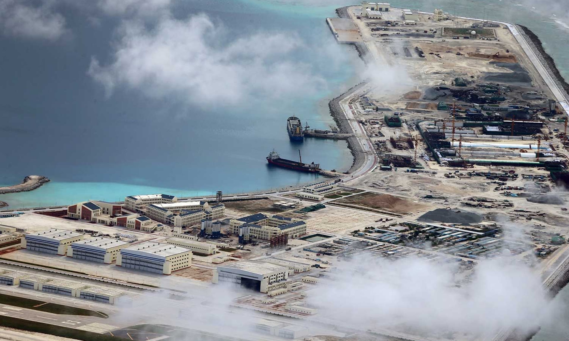
 Subi (Zamora) Reef in November.
China has spent years building military outposts on a group of contested islands in the South China Sea — a project that has left the country at odds with many of its neighbors and the United States.
First, there was the dredging, in which ships sucked sediment from the seabed and pumped it atop formerly undeveloped reefs.
Then came the buildings — once said to be for civilian purposes but which analysts now say are small military installations — followed quickly by international uproar.
But the building continued.
But the building continued.
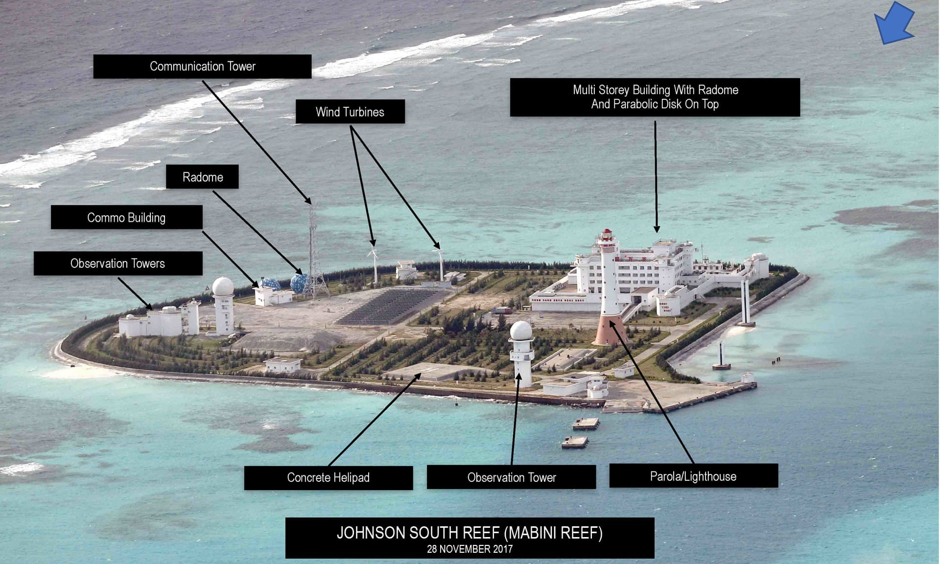
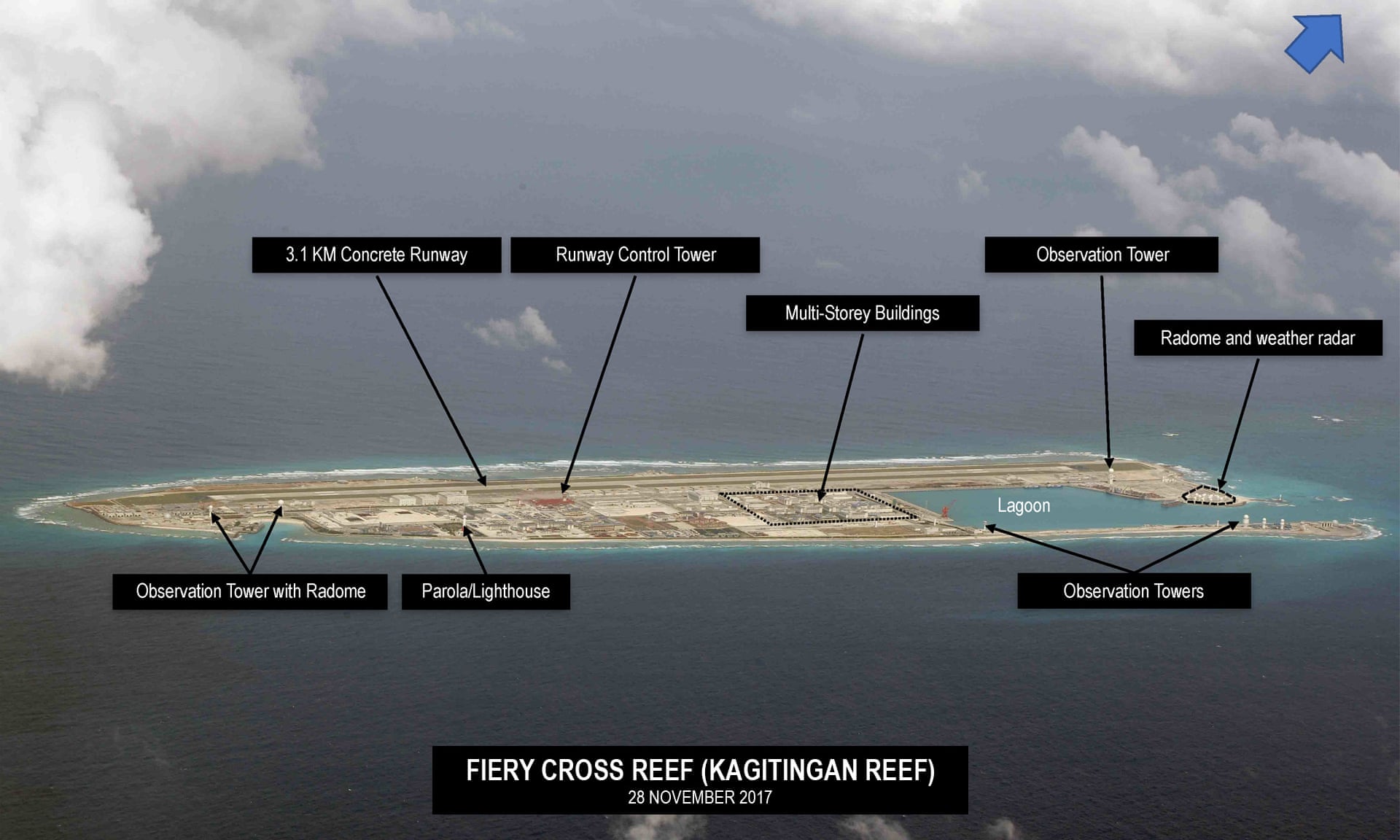
Now, some of the islands that are part of the group known as the Spratlys, where China began large-scale development in 2013, have been transformed from barren reefs into military outposts, as seen for the first time in great detail in a series of new photos.
The images, which were obtained by The Philippine Daily Inquirer from an unnamed source, offer the clearest views yet of the scale of construction and the nature of the military development.
The Pentagon and the Philippine military both declined to comment on the images.
The images, which were obtained by The Philippine Daily Inquirer from an unnamed source, offer the clearest views yet of the scale of construction and the nature of the military development.
The Pentagon and the Philippine military both declined to comment on the images.
The New York Times has been unable to independently verify these photos, which were released with annotations that indicate they were taken between June 2016 and December 2017.
But experts who monitor development in the South China Sea say the photos show the islands in dispute and are consistent with satellite imagery of the development that they have been monitoring for years.

 CreditPhilippine Daily InquirerPhoto

But experts who monitor development in the South China Sea say the photos show the islands in dispute and are consistent with satellite imagery of the development that they have been monitoring for years.

 CreditPhilippine Daily InquirerPhoto
Conor Cronin, a research associate at the Asia Maritime Transparency Initiative at the Center for Strategic and International Studies in Washington, said the buildings in the new images were at the same scale as the structures in the photographs his group regularly assesses from the region.
The initiative monitors development in an area long shrouded in secrecy.
What’s striking about these images, he said, is that for the first time, significant surface-level details can be seen.
“These are kind of rare shots to see publicly,” Mr. Cronin said, noting that the detailed views of the island, seen from a much closer angle than the satellite level, were insightful.
“It’s another indication of how well established these facilities are and kind of the capabilities they are going to have.”


 The development of the Spratly Islands has ignited outrage from neighbors that also lay claim to this portion of the South China Sea.


 The development of the Spratly Islands has ignited outrage from neighbors that also lay claim to this portion of the South China Sea.
To varying degrees, the Philippines, Vietnam and Malaysia all stake claim to parts of the area.
While tensions have eased somewhat as China negotiates an agreement with other players on a code of conduct for the region — which seems to allow economic development without resolving the underlying sovereignty disputes — the unabated pace of construction could stir fresh tensions.
Bonnie S. Glaser, a senior adviser for Asia at the Center for Strategic and International Studies, said the photos provided a unique perspective.
She said she believed, particularly given the annotations on the images, that they were most likely taken by a military aircraft.
“What is really quite stunning is how clear you can see in these aerial photos how much has been built,” Ms. Glaser said.
“What is really quite stunning is how clear you can see in these aerial photos how much has been built,” Ms. Glaser said.
“It’s really up close and personal.”
A recent assessment from the Asia Maritime Transparency Initiative of satellite imagery revealed that China had developed 72 acres, both above and below ground, in the South China Sea in 2017 alone. Since the construction first began in 2013, China has developed more than 3,200 acres across the area.
More recently, the Chinese have turned their attention from dredging and reclaiming land to building airstrips, radar and communications facilities and hangars.


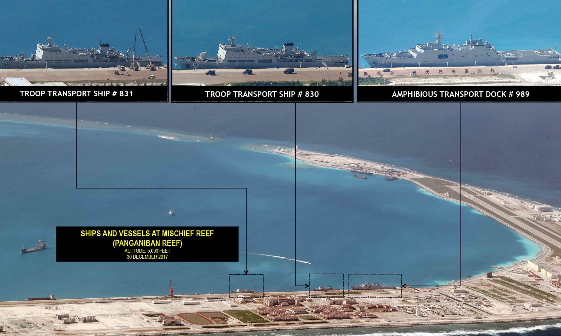
On Mischief Reef, which was once largely underwater, 1,379 acres have been developed by China. The latest images from the island purportedly show a nearly two-mile runway and concrete building. Analysts say it is only a matter of time before Chinese military planes begin landing there.
“They are going to begin to operate out of these runways and, I believe, start to actually store these aircraft, at least short term, in these hardened shelters,” Ms. Glaser said.
A recent assessment from the Asia Maritime Transparency Initiative of satellite imagery revealed that China had developed 72 acres, both above and below ground, in the South China Sea in 2017 alone. Since the construction first began in 2013, China has developed more than 3,200 acres across the area.
More recently, the Chinese have turned their attention from dredging and reclaiming land to building airstrips, radar and communications facilities and hangars.


On Mischief Reef, which was once largely underwater, 1,379 acres have been developed by China. The latest images from the island purportedly show a nearly two-mile runway and concrete building. Analysts say it is only a matter of time before Chinese military planes begin landing there.
“They are going to begin to operate out of these runways and, I believe, start to actually store these aircraft, at least short term, in these hardened shelters,” Ms. Glaser said.
“They built them for that purpose.”
China’s Ministry of Defense announced on Wednesday that it would conduct training exercises with combat jets in the South China Sea, though it did not indicate whether any of the planes were destined for the islands.
Mischief Reef — known as Panganiban Reef in the Philippines — lies about 140 miles off the coast of the Philippines and was determined by an international tribunal in The Hague to be within Philippine territorial waters.


But the ruling has not stopped China.
The Asia Maritime Transparency Initiative said in its most recent assessment of the island that construction was carried out on buildings covering 17 acres of Mischief Reef.
“This included underground storage for ammunition and other material, the completion of hangars and missile shelters, and new radar and communications arrays,” the organization wrote.
Similar details in the aerial photos point to the same conclusion.
While the negotiations over a code of conduct for development in the South China Sea with the 10-country Association of South East Asian Nations have stalled, China’s development continues.
“While they take forever to put this agreement together, China has not slowed in building up these bases,” Mr. Cronin said.
China’s Ministry of Defense announced on Wednesday that it would conduct training exercises with combat jets in the South China Sea, though it did not indicate whether any of the planes were destined for the islands.
Mischief Reef — known as Panganiban Reef in the Philippines — lies about 140 miles off the coast of the Philippines and was determined by an international tribunal in The Hague to be within Philippine territorial waters.


But the ruling has not stopped China.
The Asia Maritime Transparency Initiative said in its most recent assessment of the island that construction was carried out on buildings covering 17 acres of Mischief Reef.
“This included underground storage for ammunition and other material, the completion of hangars and missile shelters, and new radar and communications arrays,” the organization wrote.
Similar details in the aerial photos point to the same conclusion.
While the negotiations over a code of conduct for development in the South China Sea with the 10-country Association of South East Asian Nations have stalled, China’s development continues.
“While they take forever to put this agreement together, China has not slowed in building up these bases,” Mr. Cronin said.
“They are continuing apace.”


